
Keyword
Earth Science | Oceans | Ocean Circulation | Upwelling/Downwelling
12 record(s)
Type of resources
Topics
Keywords
Contact for the resource
Provided by
Formats
Update frequencies
Status
draft
-
ESRI shape file showing ocean upwelling around Australia. This shape file was produced from a hand drawn map showing upwelling around Australia. The hand drawn map is a qualitative summary of published information on upwelling. The shape file has been produced by CSIRO for the National Oceans Office, as part of an ongoing commitment to natural resource planning and management through the 'National Marine Bioregionalisation' project. Data shown is qualitative.
-
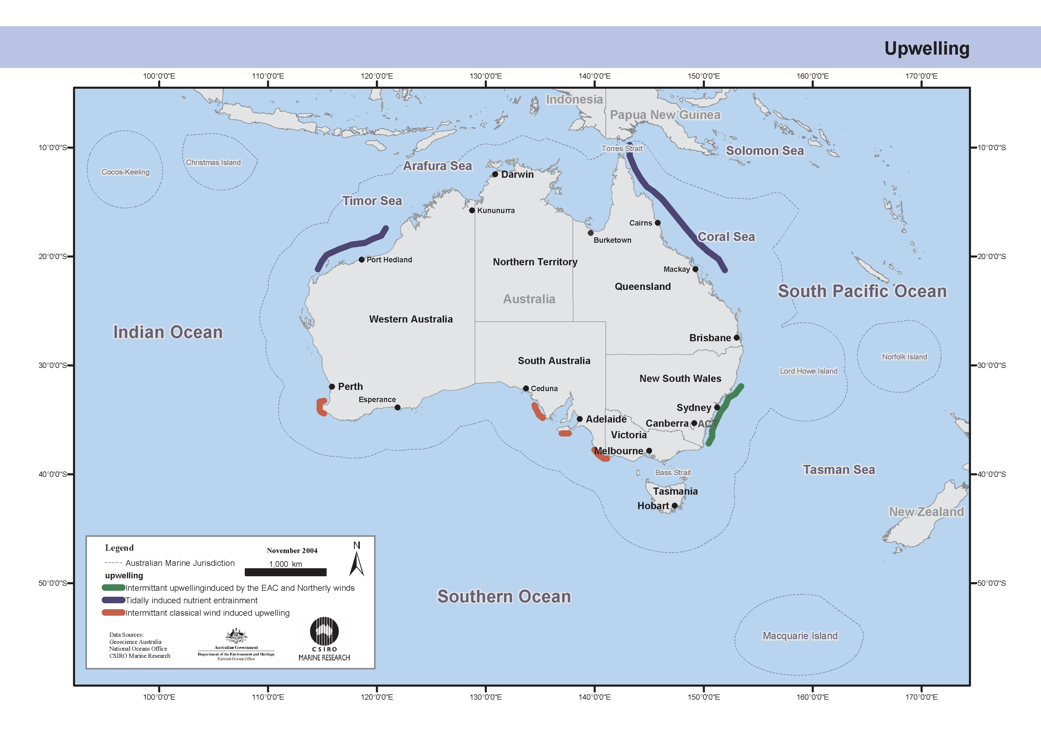
This map was produced from a hand drawn map showing upwelling around Australia. The hand drawn map is a qualitative summary of published information on upwelling. Upwelling around Australia tends to be intermittent and localised, and thereby make only a relatively modest contribution to total primary production. A range of processes are responsible for the upwelling that does occur. In a system with classical wind-driven upwelling, surface waters are pushed away from the coast by wind-stress to be replaced by cold nutrient-rich waters from the deeper shelf. Such events have usually been observed in summer off southwestern Australia and in parts of the Great Australian Bight when winds are favorable to upwelling. On the NSW coast, significant upwelling only occurs when northerly winds and encroaching eddies from the East Australia Current combine to bring water from the outer-shelf and upper-slope into the surface waters of the inner shelf. A third mechanism applies to some tropical waters, where tidal motions over the steep upper slope generate large internal waves that subsequently break and mix deeper nutrient-rich waters up into the surface layer. This map has been produced by CSIRO for the National Oceans Office, as part of an ongoing commitment to natural resource planning and management through the 'National Marine Bioregionalisation' project. Data depicted is a qualitative summary of published information. Variations in onscreen colour representation or printed reproduction may affect perception of the contained data.
-
Single beam calibrated acoustic data collected by MUFTI-2, a deeply towed instrument with four frequencies at 18, 38 , 70 and 120 kHz. Collected during July voyage to quantify the biomass of orange roughy at St Helens Hill and St Patricks Head. Other data collected during this voyage was Simrad EK60 single beam acoustics from the Bluefin's vessel mounted echosounder and also Simrad ES60 at 38 kHz from catcher vessel FV Adriatic Pearl.
-
The eddy-resolving Ocean Forecasting Australia Model (OFAM) is used to downscale future climate projections by CSIRO Mk3.5 climate model under scenario A1B for the 2060s. A simulation run without relaxation and another run with relaxation to expected sea surface temperature and sea surface salinity are archived with 3D fields of ocean temperature, salinity, currents, and sea surface height.
-
Trawl catch data from deepwater commercial trawl net and MIDOC fine mesh midwater sampling net deployed from catcher vessel FV Adriatic Pearl. The dataset contains species, length, weight, sex and stage.
-
Simrad calibrated EK60 vessel mounted vertical acoustic data at 38 kHz during July voyage to quantify the biomass of orange roughy at St Helens Hill and St Patricks Head. Other data collected during this voyage was MUFTI-2 deep towed body acoustic data at 18, 38 ,70 and 120 kHz and also Simrad ES60 at 38 kHz from catcher vessel FV Adriatic Pearl.
-
The eddy-resolving Ocean Forecasting Australia Model (OFAM) is used to downscale future climate projections by CSIRO Mk3.5 climate model under scenario A1B for the 2060s.
-
Simrad calibrated ES60 vessel mounted vertical acoustic data at 38 kHz during July voyage to quantify the biomass of orange roughy at St Helens Hill and St Patricks Head collected by catcher vessel FV Adriatic Pearl. Other data collected during this voyage was MUFTI-2 deep towed body acoustic data at 18, 38 ,70 and 120 kHz and also Simrad EK60 at 38 kHz from acoustic survey vessel FTV Bluefin.
-
This dataset contains temperature data from the West Indian Ocean. Data (including available XBT data) were collected since 1778. They have been subjected to quality control as an activity of CSIRO and BoM.
-
This dataset contains temperature data from the East Indian Ocean. Data (including available XBT data) were collected since 1778. They have been subjected to quality control as an activity of CSIRO and BoM.